Melbourne train map
You can find on this page the Melbourne trains map to print and to download in PDF. The Melbourne trains map presents the rail network and railway stations of the trains of Melbourne in Victoria - Australia.
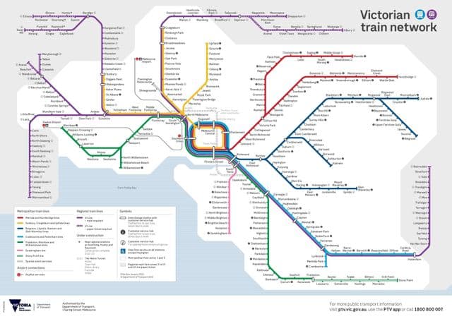
Melbourne rail map
The Melbourne rails map shows all the railway stations and lines of Melbourne trains. This railway map of Melbourne will allow you to easily plan your route with the trains of Melbourne in Victoria - Australia. The Melbourne rails map is downloadable in PDF, printable and free.
Australia second largest city has some 5.3 million inhabitants. The rapid rail system serving the Melbourne is actually not a metro or subway service in the classical sense but a frequent suburban train service which runs in a 4-track underground loop in the centre of Melbourne as you can see in Melbourne rail map. Depending on the time of the day trains run around the city loop clockwise or anti-clockwise. Sandringham trains leave from Flinders Street station without running around the loop. Stations on the suburban network are closely spaced, some 500-1000 m apart, but there are numerous level crossings on most routes outside the central area. Since 2009, the Melbourne metropolitan rail system (1600 mm gauge) has been operated by Hong Kong MTR, now branded as “Metro”.