Melbourne topographic map
You can find on this page the Melbourne topographic map to print and to download in PDF. The Melbourne elevation map present the topography, river and relief of Melbourne in Victoria - Australia.
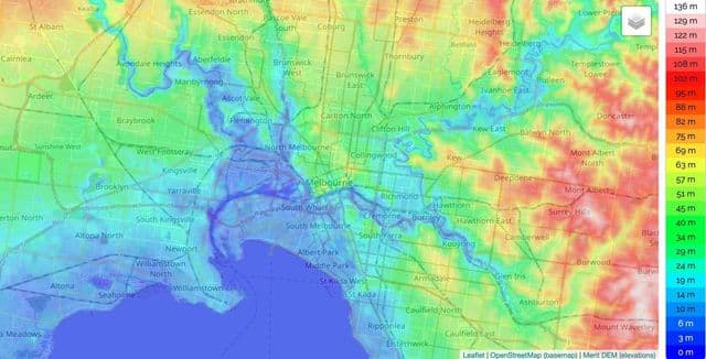
Melbourne elevation map
The Melbourne topographic map shows elevation, hills and landforms in Melbourne. This elevation map of Melbourne will allow you to know topography, river and relief of Melbourne in Victoria - Australia. The Melbourne topographic map is downloadable in PDF, printable and free.
The City of Melbourne municipality is located at latitude 37 degrees 49 minutes south and longitude 144 degrees 58 minutes east on the south-east edge of Australia. Focused around a central business district, metropolitan Melbourne suburbs spread more than 40 km to the south, are hemmed in by the Dandenong ranges 30 km to the east, extend up to 20 km to the north and sprawl across vast, flat basalt plains to the west. Victoria contains many topographically, geologically and climatically diverse areas, ranging from the wet, temperate climate of Gippsland in the southeast to the snow-covered Victorian alpine areas which rise to almost 2,000 m (6,600 ft), with Mount Bogong the highest elevation peak at 1,986 m (6,516 ft) as its shown in Melbourne elevation map.